Ridgefield Historical Society staff and researchers from Heritage Consultants, LLC are documenting areas in town where fighting occurred in addition to the three most well-known engagements along Route 116.
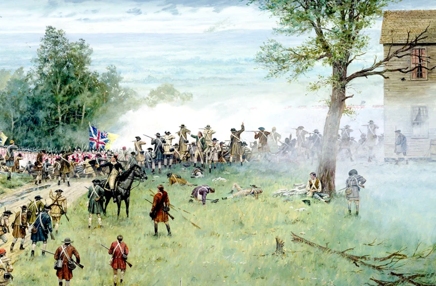
The First Engagement occurred in the vicinity of Barlow Mountain Road and North Salem Road where Wooster’s Division of American troops overran the rear of the British column. The Second Engagement occurred near the junction of North Salem Road and Tackora Trail where General Wooster fell wounded and his division was repulsed by British infantry and artillery. The Third Engagement was fought along the northern end of Main Street from the Danbury Road to where the British broke through American defenses at the barricade across the road near Olcott Way.
What is less known is the fighting that occurred throughout town afterwards which may be described as a Fourth Engagement. In 1927 historian George Rockwell wrote that after the barricade the “battle did not end in Ridgefield at this time. Firing was kept up all day through the street, along East Ridge, across the hill…continuing south on the Whipstick Ridge…the British placed a cannon in front of the Episcopal Church…and several shots were fired down the street.”
His detailed account was based on both oral tradition and physical evidence in the form of 3-pound iron cannonballs, lead shot, buttons, and other artifacts uncovered by townspeople throughout the nineteenth and early twentieth centuries. Rockwell goes on to note that “several cannon balls have been found on Main Street” and “on High Ridge” and details areas in town where they were found, the most notable example being “the Keeler Tavern” which is still visible today.
Lieutenant Robertson of the British Royal Engineers recorded a few sentences in his journal which provides some insight into events following the Third Engagement. Robertson noted that “After being in the Village a little while the Rebels again drew together and came up to gain a Rising Ground above the Village, upon which Sir William Erskine made a Disposition to surround them. However, by the different Companys not advancing at the same time, we only Dispersed them and drove them off” indicating that American troops reformed in the village and took position of some high ground which required several British regiments to drive them off.
Over the years additional artifacts were located throughout town and as recently as 2020 local detectorists uncovered lead musket balls and both American and British uniform buttons on private property on the southern end of Main Street which provide some additional clues to what may have occurred during the Fourth Engagement.
The Ridgefield Historical Society is currently accepting permission forms from landholders along the Route 116 battlefield route, the George Washington Highway, High Ridge, and Soundview Road. Please contact the Ridgefield Historical Society at [email protected] or call (203) 438-5821 if you would like to participate in this exciting project.
Please join our email list for the latest findings and news!
In recognition of the national significance of the April 27, 1777 Battle of Ridgefield, the National Park Service (NPS), American Battlefield Protection Program (ABPP) awarded the Ridgefield Historical Society and the Connecticut State Office of Historic Preservation a Research and Documentation Grant to study the engagement. The scope of the grant includes renewed historical research efforts to reconstruct the Battle of Ridgefield, determine where actions occurred related to the battle, assess the integrity of contributing properties for a possible future archaeological survey, and build community support and seek landholder permissions. Ridgefield Historical Society staff and researchers from Heritage Consultants, LLC are documenting areas in town where fighting occurred in addition to the three most well-known engagements along Route 116 and Main Street. The research team mapped battle-related artifacts recently identified through historical research and public outreach efforts. The results suggest that skirmishing between British and American forces occurred throughout the day in areas well beyond the three famous engagements. With landholder permission, an archaeological survey of these newly identified areas could yield additional evidence of battle and enrich our understanding of what happened during the Battle of Ridgefield.