Maps
Listed by year of publication
Click on the PDF icon to download a high-resolution file. Click the thumbnail to view on screen.
1812 Map of Connecticut (Warren)
Warren’s Map of Connecticut shows Ridgefield when it extended north to the New Fairfield border.
1856 Map of Fairfield County (Clark)
Richard Clark’s 4 by 5 foot (in the original) hand-colored wall map of Fairfield County, showing almost every house and other major building, with owners’ names.
1856 Map of Main Street, Ridgefield (Clark)
Village map inset from Clark’s map (above).
1867 Ridgefield Town Map (Beers)
From the 1867 Beers Atlas of Fairfield and Westchester Counties, detailed map of town showing almost every house and other major building, with owners’ names.
1867 Ridgefield Main Street (Beers)
Village map inset from Beers’s map (above).
1867 Map of Titicus (Beers)
Titicus map inset from Beers’s map (above).
1867 Map of Greater New York City Region (Beers)
This huge map from the Beers Atlas includes Ridgefield and the complete planned routes of the two railroad lines proposed to run through the town that were never completed. Hand-colored and with considerable detail.
1892-1928 US Geological Survey Map
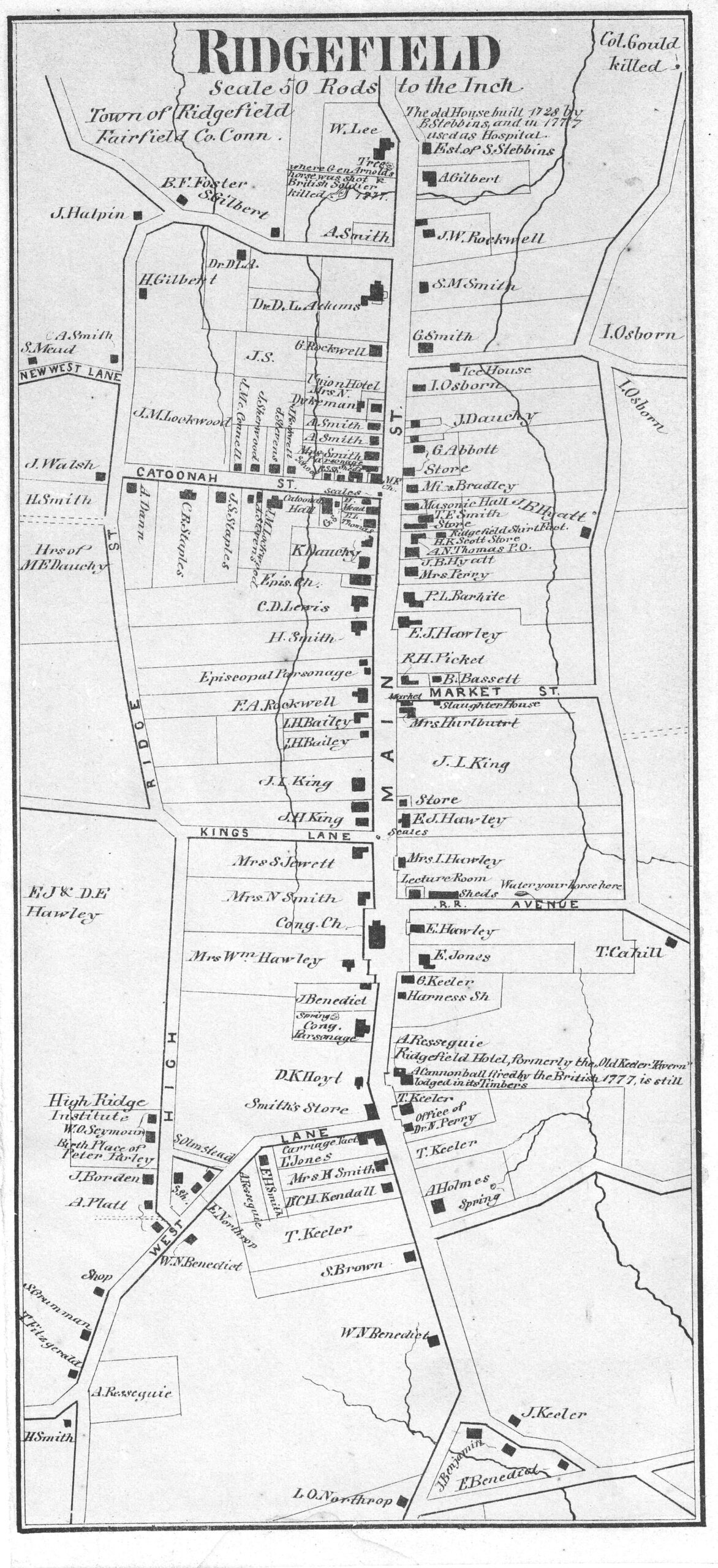
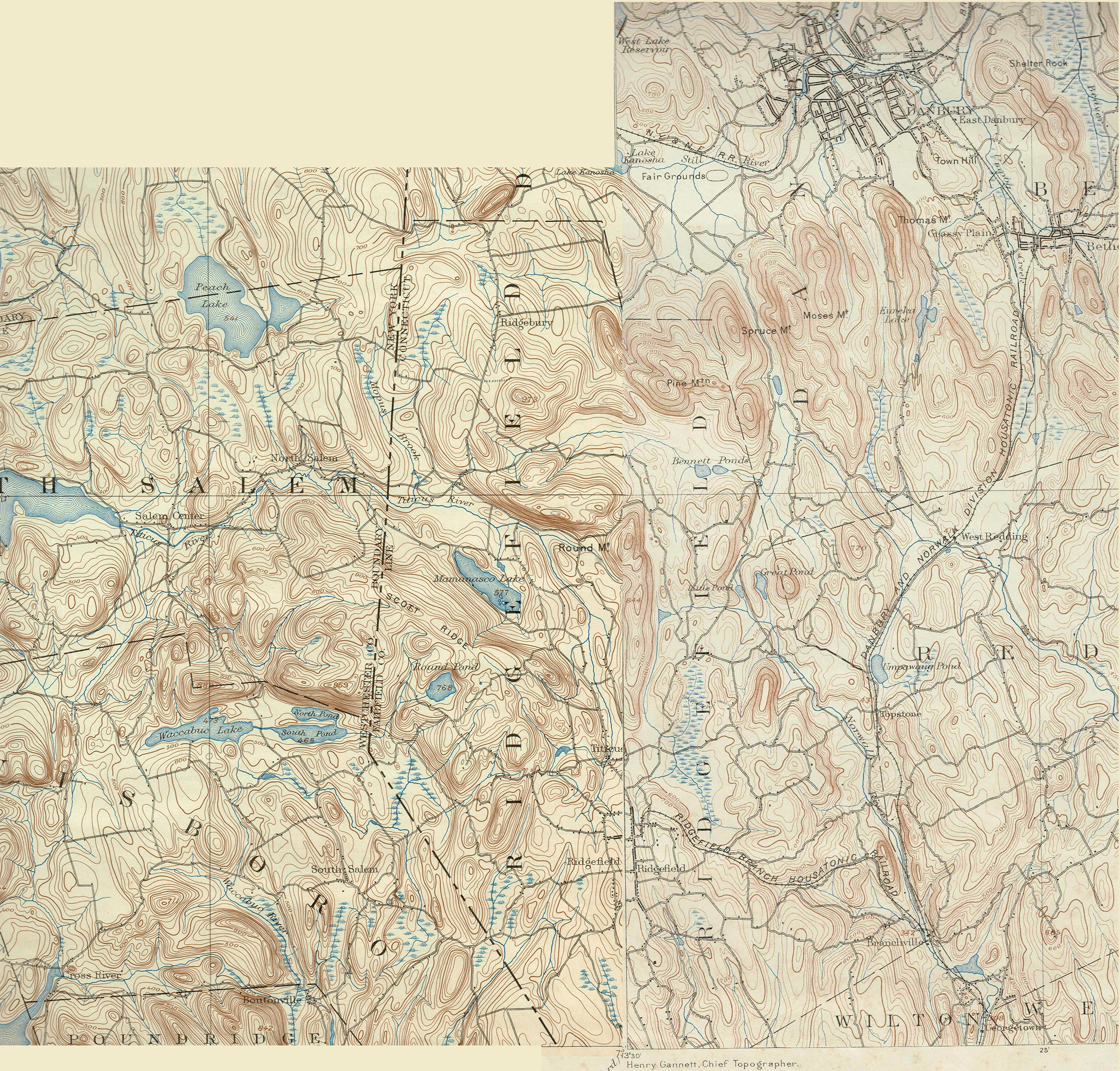
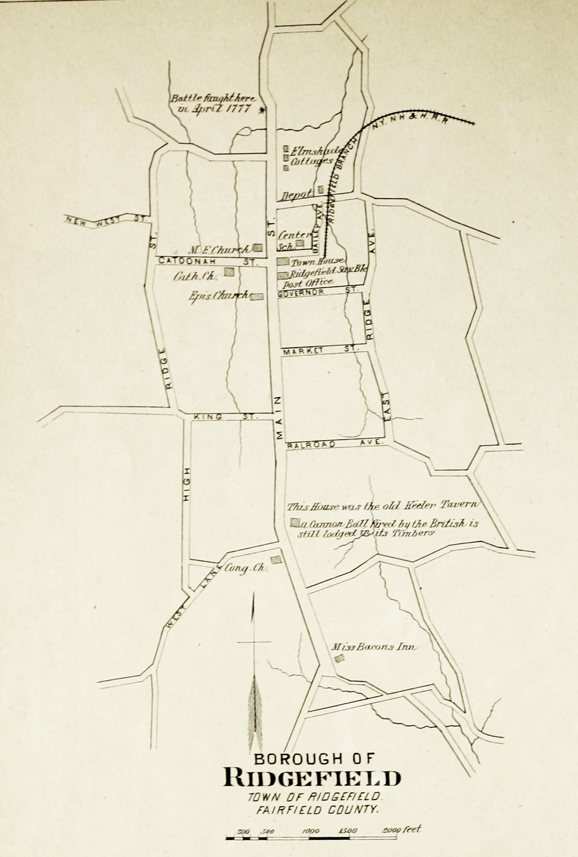
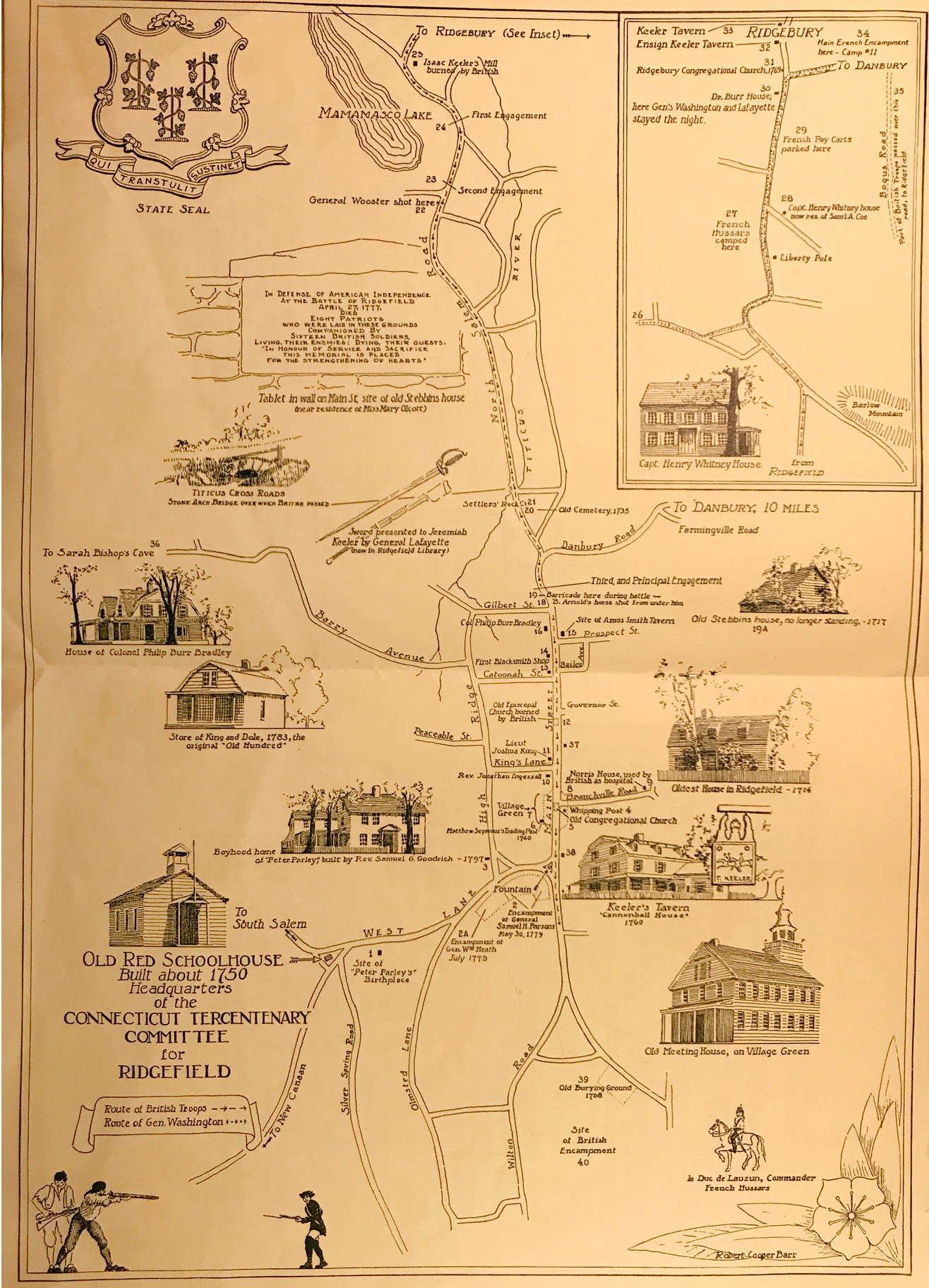
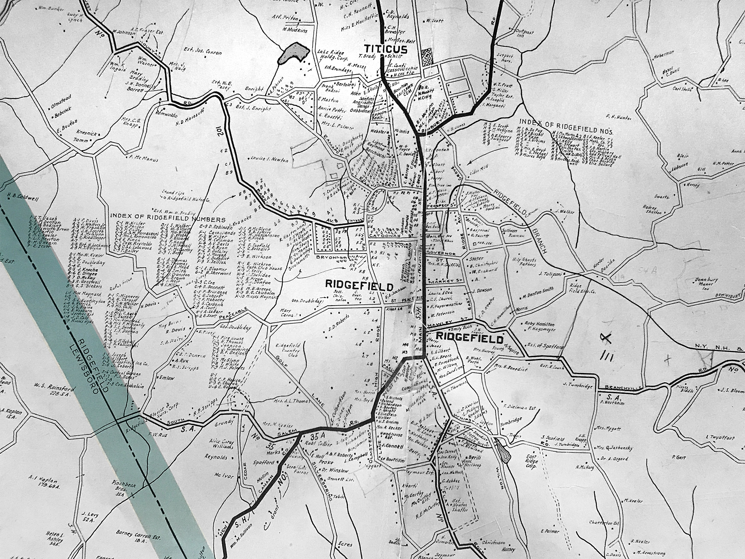
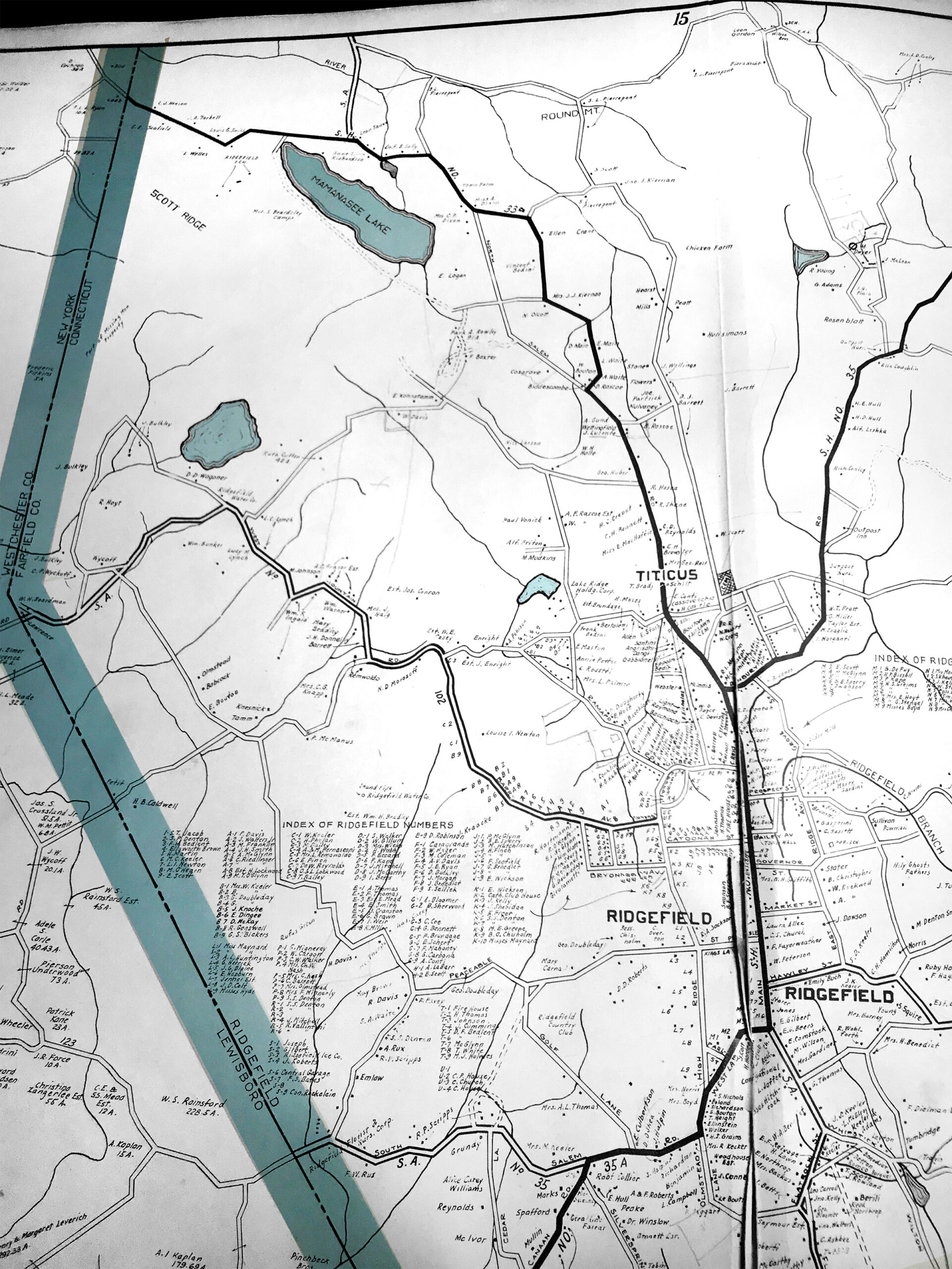
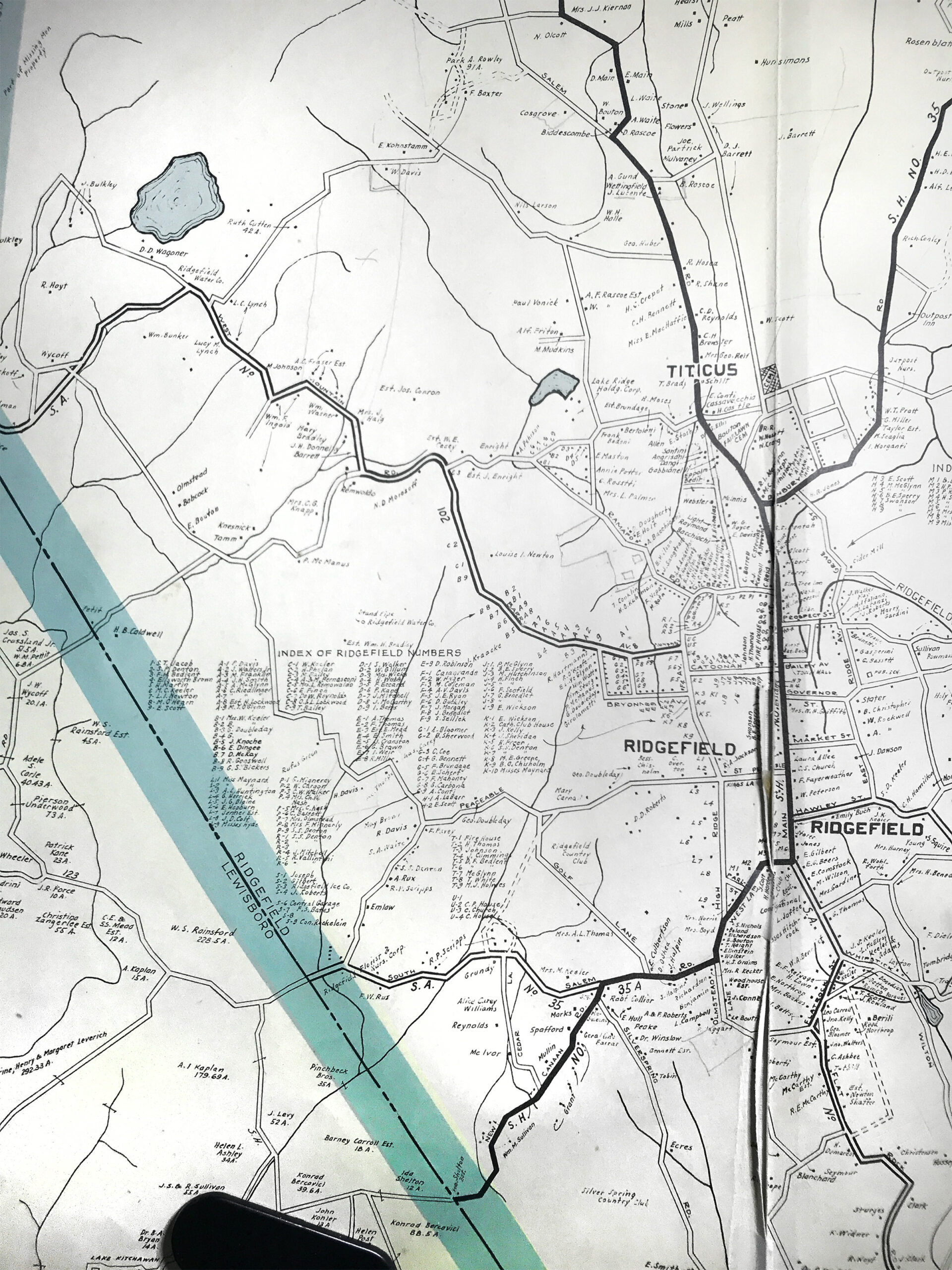
This is two, joined, topographic maps. The left half was drawn in 1892; the right half, 1928. Together they show Ridgefield features a century or more ago, with some old now-abandoned roads and before the creation of the Ridgefield Lakes, Lake Windwing, Lake Pierrepont, and several other man-made bodies of water.
1893 Atlas – Ridgefield Borough (Hurd)
Map of the village (borough) of Ridgefield from Hurd’s atlas (available under Books).
1899-1900 Map of Ridgefield Village
This map, used to determine where the town’s new sewer system would be installed, is useful because it shows property owners in the village in the late 1890s, as well as the locations of buildings.
1906 North Ridgefield Map (Hyde)
Northern half of Ridgefield, from E. Belcher Hyde’s Atlas of Westchester County, with many lot lines, buildings and owners’ names. Very detailed.
1906 Map of South Ridgefield and Lewisboro (Hyde)
Southwestern quadrant of Ridgefield, from Hyde’s Atlas (as above). Includes center of town.
1912 Map of Ridgefield (Minor)
Henry R. Minor map of Ridgefield, with all houses and owners/occupants.
1935 Battle of Ridgefield Route Map (Barr)
A graphically illustrated map (by Robert Cooper Barr) of the British route through Ridgefield in April 1777, created in 1935 for the Connecticut Tercentennial.
1936 Dolph & Stewart Atlas, Center of Ridgefield
Dolph & Stewart atlas, center of town, with names of owners.
1936 Dolph & Stewart Atlas, East Side of Ridgefield
Dolph & Stewart atlas, east side of town, with names of owners.
1936 Dolph & Stewart Atlas, North Side of Ridgefield
Dolph & Stewart atlas, north side of town, with names of owners.
1936 Dolph & Stewart Atlas, West & Central Ridgefield
Dolph & Stewart atlas, west and central part of town, with names of owners.
1936 Dolph & Stewart Atlas, Southwest & Central Ridgefield
Dolph & Stewart atlas, southwest part of town, with names of owners.
1946 Zoning Map
This was the first town zoning map produced by the Zoning Commission, which was established in 1946.
1952 Ridgefield Planning Map, South Half
Official town map, south half of town, with owner names; with Ridgefield Lakes inset.
1952 Ridgefield Planning Map, North Half
Official town map, north half of town, with owner names; with Ridgefield Lakes inset.
1958 Richard Scarry Battle of Ridgefield Map
Richard Scarry map of the Battle of Ridgefield (no key to numbers, alas).
2018 Zoning Map
The official town zoning map as of February 2018, showing all then-existing lots.
In This Section
- 1812 Map of Connecticut
- 1856 Map of Fairfield County
- 1867 Ridgefield Town Map
- 1867 Map of Greater New York City
- 1892-1928 US Geological Survey Map
- 1893 Atlas – Ridgefield Borough
- 1899-1900 Map of Ridgefield Village
- 1906 Ridgefield Map
- 1912 Map of Ridgefield
- 1935 Battle of Ridgefield Route Map
- 1936 Dolph & Stewart Atlas
- 1946 Zoning Map
- 1952 Ridgefield Planning Map
- 1958 Richard Scarry Battle of Ridgefield Map
- 2018 Zoning Map