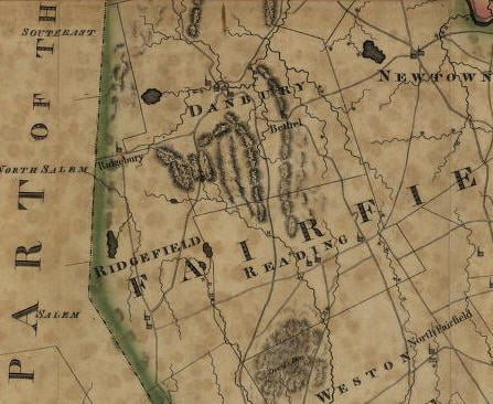
Warren’s map of 1812

Large boulder at edge of Fairlawn Cemetery on North Salem Road, opposite New Street, where, legend says, five Norwalk men, exploring for the new settlement of Ridgefield, spent a night.
Moses Warren's Map of 1812

NUGGET #64

Moses Warren’s map of Connecticut, published in 1812 in Hartford, shows, for the first time, the new route between Ridgefield and Danbury through the Sugar Hollow; Ridgefield village’s two churches in their proper places along the west side of Main Street; also shows “The Crank” in Ridgebury [the section along George Washington Highway that was once ceded to Danbury, but was returned to Ridgefield]; one of last maps to show Ridgefield extending to New Fairfield.

Search

More Posts

On Board with Sara Kaplan

An architect and artist with a deep appreciation for Ridgefield’s history shares how her love for the town led to her involvement with the Ridgefield Historical Society.

From the Collection: Conklin’s Dairy

A simple glass milk bottle from the 1940s offers a glimpse into Ridgefield’s agricultural past and the era of home-delivered milk from local farms.

Seeking a Social Media Intern

Love history and content creation? This paid summer position offers a chance to craft compelling digital stories about the people and places that shaped Ridgefield.

Send Us A Message

Subscribe to Our Newsletter

Join our mailing list and receive updates, news, and invitations.

Visit Us

Ridgefield Historical Society
4 Sunset Lane
Ridgefield, CT 06877
Tel. (203) 438-5821

Community

 © 2025 Ridgefield Historical Society, All Rights Reserved | Privacy Policy