By Dr. David Leslie
Heritage Consultants, LLC, archaeologists, metal detectorists, and Ridgefield Historical Society members have been hard at work over the past few months identifying traces of the Battle of Ridgefield throughout town, including vestiges of the First, Second, Third, and Fourth Engagements. To-date, these efforts have largely focused on the physical artifacts left behind from the battle (musket balls, military buttons, edged weapons, buckles, etc.) and any historical references or maps of the battle. Another technique we have also been employing to search the town for remnants of the battle is ground penetrating radar (GPR). While metal detection is used to find buried metal artifacts, GPR is a technique that allows archaeologists to identify buried features, such as the foundation for the Stebbins House, an integral part of the Barricade at the Third Engagement, or grave shafts associated with burials following the battle.
GPR is a non-invasive technique that utilizes radio waves emitted from an antenna and relayed to a computer to map features buried beneath the ground surface. The image below displays an idealized schematic of objects and features buried beneath the ground surface that are reflective when imaged via GPR. The second image displays the same schematic, but with actual radargrams or the output from GPR, where the features appear as vertical breaks within the normal layers of earth, or stratigraphy, beneath the surface.
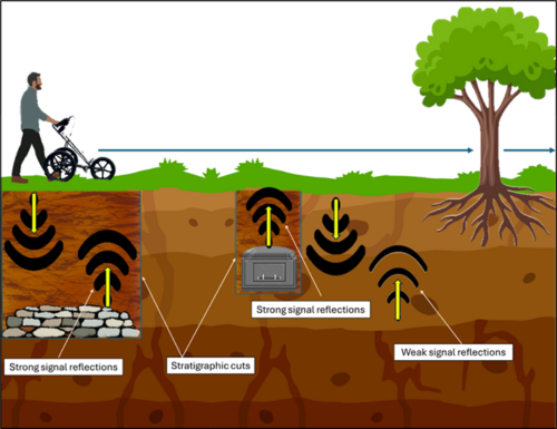
Idealized schematic of GPR data collection, with features that provide strong signal reflections to GPR energy.
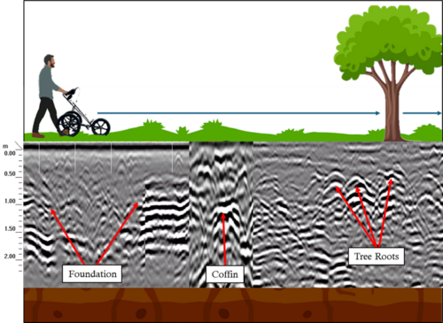
Schematic of GPR data collection, with actual radargrams of buried features, as indicated by labels.
In Ridgefield, GPR has been and will be used to identify several underlying features associated with the battle. The most important features to identify include the foundation of the Stebbins house, which likely sits between a small lot owned by the Town and the Casagmo Condominium Association. Identifying the location of the Stebbins House is of critical importance to grounding the location of the Third Engagement, as we know that this house was an integral part of the Barricade erected by Generals Arnold and Silliman, while General Wooster harried (and delayed) the British forces in the Second Engagement. This area is also particularly sensitive for battle related features, as we know that at least 18 casualties from British and American forces are buried in this general area. Recent archaeological evidence from a nearby property indicates that at least five individuals were buried nearby and were likely casualties of the Battle. These individuals were buried without their uniforms and because combatants from both sides were made up of militiamen (Prince of Wales Loyalist and Connecticut Militia), it is challenging to identify if they are Patriot or British dead. The Connecticut Office of State Archaeology is currently working with the Ridgefield Historical Society to conduct forensic identification of these individuals, to properly honor and re-inter them.
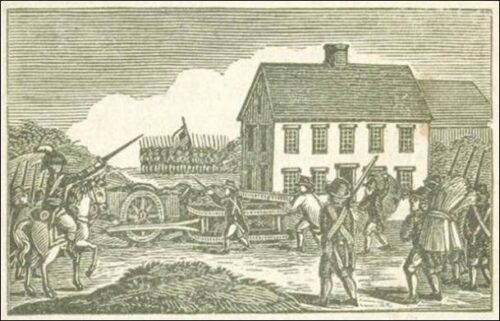
Woodcut of the Third Engagement and Barricade at the Battle of Ridgefield.
Preliminary GPR results from this area indicate that the underlying soils and geology that made the barricade such a defensible position remain largely intact. Radar results from nearby property owners also indicate that at least four additional burials might lie in the general vicinity of the Third Engagement. In the coming weeks, as the snow melts, we plan to fully survey the town owned lot adjacent to the Casagmo Condominium Association. One of the goals of this research is to document the final resting place of Patriot and British men who died during the Third Engagement. Identifying the physical location of the Stebbins House, and thus the barricade, will aid in this search tremendously.
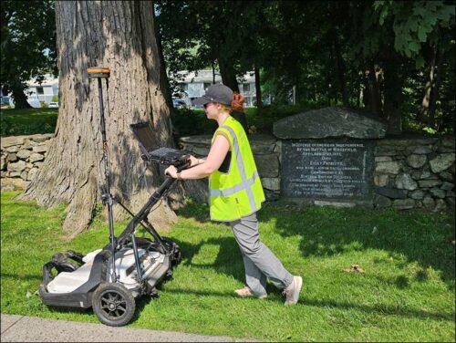
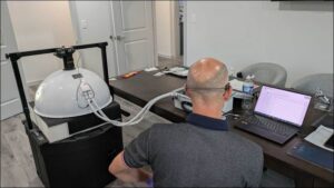
Fiona Jones collecting GPR data within the area of the Barricade and purported location of Patriot and British burials.
The Battle of Ridgefield archaeological project, funded by a National Park Service grant, is a project of the Ridgefield Historical Society, with Heritage Consultants LLC, the professional team charged with exploring and documenting evidence of the battle’s boundaries, engagements and participants. A first phase of this effort was completed in 2022, when documentation and mapping were undertaken. Now, hands-on archaeological work is the primary focus of the team, which has been working at a variety of locations throughout the battlefield area. Monthly blog posts by the archaeologists provide updates on discoveries.